No one likes getting lost. Few things can bring a fun excursion into new territory to a grinding halt faster than finding you've driven the family out to the middle of nowhere with a quickly emptying gas tank. Tempers flare, harsh words are used, and trips can be ruined.
Thankfully, our friend science has given us the Global Positioning Satellite system. Russia launched the first rocket with its unveiling of Sputnik in 1957, and ever since, humanity has found ways of taking advantage of this new ability to send things into space.
We're featuring four of the most popular GPS manufacturers on the market today. Units are getting smaller and cheaper all the time; if you haven't already, now may be the perfect time to take the plunge into satellite-directed travel.
 Garmin GPSMAP 640
Garmin has been a leader in GPS technology for years, and its GPSMAP 640 is a great addition to the family. The 640 is an ultra portable and rugged touch screen navigator that comes preloaded with a comprehensive set of street maps and marine charts. Garmin also offers the GPSMAP 620, which shares the same intuitive interface and is designed for markets outside the United States.
Portable and powerful, the GPSMAP 600 series features a high-sensitivity GPS receiver and boasts an intuitive, waterproof (IPX7) super- bright 5.2-inch WVGA touch screen display (800 by 480 pixels) that reacts as users tap or drag through intuitive menus and options. The GPSMAP 640 comes preloaded with comprehensive street maps of North America and worldwide shaded relief mapping in addition to detailed U.S. coastal BlueChart g2 charts for boaters. When placed in its marine mount, included standard, these new portables automatically start up in marine mode, presenting chart features such as shaded depth contours, port plans, wrecks, restricted areas and more.
With optional BlueChart g2 Vision technology, the GPSMAP 640 provides a true 3-D "mariner's-eye view," for a navigation perspective above the waterline, and a "fish-eye view" for an underwater 3D bathymetric contour perspective. Mariners will also benefit from an auto guidance technology that offers the best navigational route. In addition, photo references give detailed aerial views of points of interest (POI) such as ports, marinas, waterways and landmarks.
When boaters are ready to pack up and hit the road, the GPSMAP 640 effortlessly snaps off its marine mount and, when placed in the automotive mount, quickly transitions into a robust automotive navigator. On the road, this device gives voice-prompted turn-by-turn directions, advising you to "turn right on Main Street." In planning a route, users can search for a local bait shop or the best resorts around town and the GPSMAP will lead the way. With the GPSMAP 640, users can also create custom POIs and set up proximity alerts for the ultimate in driver awareness.
Additionally, with the GXM 40 antenna (sold separately), the GPSMAP 640 can graphically display XM WX Satellite Weather data directly on the unit's display. More than 20 different types of weather attributes - information such as NEXRAD, wind speeds, visibility, severe weather storm tracks and more - deliver location-specific data, in chart-overlay form, directly to the device. With the GXM 40, motorists and mariners also have the option of receiving nearly 200 channels of commercial-free music, news, sports talk and entertainment with XM Satellite Radio. To steer clear of traffic backups, XM NavTraffic is also available to motorists with the GXM 40 antenna. For more information and availability, visit www.garmin.com.
Magellan Triton 2000
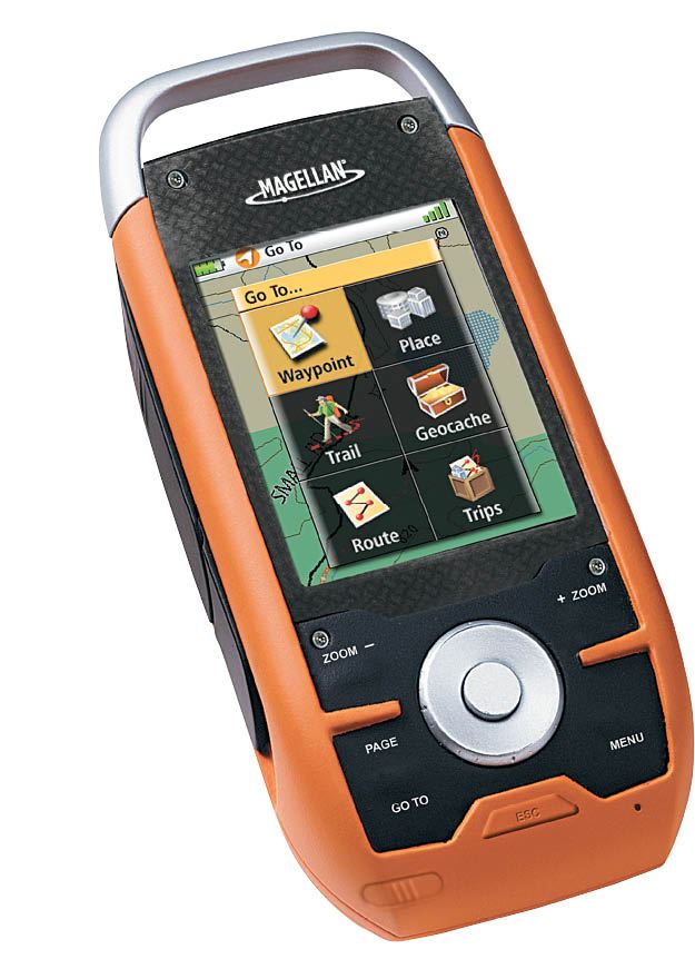

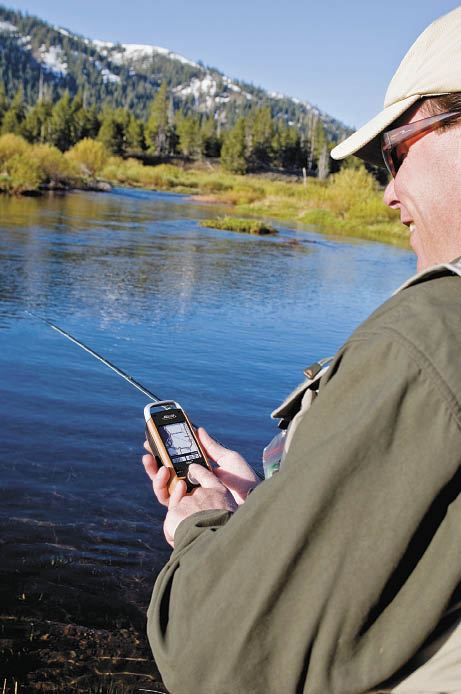 Own the outdoors with the Magellan Triton series! You no longer need to purchase a larger, boat-mounted GPS device for your excursions out on the water; the Triton 2000 is reinventing outdoor GPS with its easy-to-use menus and advanced features, making it an excellent GPS for all your outdoor activities. Whether you are cruising across the lake, locating your favorite fishing hole or taking the family on an exciting outdoors adventure, the Magellan Triton GPS series, maps and accessories will make your experience fun and safe. The Triton 2000 is readable in sunlight, as the backlit QVGA color screen allows for easy viewing outdoors. The device is built to IPX-7 standards, making it rugged and waterproof, and protecting against an unexpected rain shower the spray from a nearby boat. The fast processor speed and SiRFstarIII GPS technology combine to provide quick location acquisition. Power, supplied by two standard AA batteries, makes it easy to stock up for the long trip or find spares at the local general store Advanced software features make the Triton 2000 a well-prepared travel companion, and it is compatible with a variety of highly detailed mapping products and VantagePoint PC software for pre-trip planning, accurate on-the-water information and post-trip review. Vertical profiling allows view elevation changes for a 3-D record of your entire trip, while Hunt & Fish and Sun & Moon features supply a digital almanac in the palm of your hand. The Triton 2000 supports WAAS and EGNOS for enhanced location accuracy up to three meters in North America and Europe. More information on the Triton 2000 can be found at www.magellangps.com.

 Lowrance HDS-8 and HDS-10
Lowrance introduced these 8- and 10-inch high-definition systems (HDS), the HDS-8 and HDS-10, earlier this year. The high-performance GPS chartplotter and fishfinder combination units are the first products on the market to combine high-definition navigational capabilities and Lowrance's award-winning Broadband Sounder functionality into a single, easy-to-use system. A fully networkable and expandable electronics solution, the HDS-8 and -10 offer high-definition digital radar, and Sirius weather and radio options as well as other advanced capabilities. These units are ideal for boaters who are designing an electronics package that best suits their needs throughout the boat. The Lowrance HDS-8 and -10 deliver excellent functionality in an easy-to-use, expandable package.
HDS-8 and -10 sonar models incorporate the award-winning Lowrance Broadband Sounder technology, which is proven to find more targets with greater sensitivity and higher definition. The result is superior target separation in all cover, in thermoclines and in surface clutter. With Broadband Sounder technology, sonar displays show less noise and more targets with crystal-clear clarity. Greater shallow-water detail and coverage are achieved (120 degrees of coverage at 83 kHz operation), as well as incredible deep-water performance, even at higher boat speeds.
Offering powerful out-of-the-box navigational functionality, the HDS-8 and -10 include an internal 16-channel GPS+WAAS antenna and feature a new enhanced U.S. base map that provides coverage for more than 100,000 bodies of water and nearly 5,000 lake maps with detailed shorelines and depth contours. Select HDS models also include Lowrance's new exclusive Insight cartography. Featuring stunning life-like perspectives of bottom structure and topography, Insight delivers a new dimension in effective, reliable marine navigation and fishing. Ensuring boaters have the flexibility to use their choice of cartography, the HDS-8 and -10 are compatible with Lowrance Fishing HotSpots, LakeMaster ProMaps, NauticPath, FreedomMaps, and also offer full Navionics cartography support, including Platinum+, Platinum and HotMaps Platinum capability.
The HDS-8 and -10 are equally suited for use as standalone devices or integrated into a sophisticated system via Ethernet and NMEA 2000 networks. The units are designed for ease-of-use in all conditions, incorporating a newly designed user interface and menu system that offers convenient access and control to even the most powerful features and capabilities.
The HDS-8 and -10 incorporate the latest SolarMAXTM PLUS display ensuring astounding detail and clarity. Providing unmatched high-definition fishfinding and navigational detail, the HDS-8 and -10 feature 8.4- and 10.4-inch full Super VGA displays, respectively. Both models offer an enhanced high-brightness, sunlight-viewable screen with extremely wide viewing angles. All HDS screens and keypads are fully backlit and adjustable to dim-to-zero for ease of viewing in all lighting conditions.
The HDS-8 and -10 offer SIRIUS real-time weather and stereo-quality radio support with inland and coastal package options, as well as Navico's exclusive Track-Your-Buddy and Get-Buddy features when interfaced with Lowrance-compatible VHF marine radios. The HDS-8 and -10 are available in combination Fishfinder-Chartplotter and Chartplotter-only models (the HDS-8m and HDS-10m). All Lowrance HDS systems are compatible with Lowrance HD radar systems, fully waterproof (IPX7) and are protected by a newly expanded 2-year limited warranty, with a two-year extended warranty option.
Models and Availability
The Lowrance HDS-8 and HDS-10 model options are available with the Insight USA map or enhanced U.S. basemap. Dual-frequency transducer packages are also available from Lowrance in 83/200 kHz and 50/200 kHz options. The HDS-8 and HDS-10 models can be purchased through authorized Lowrance dealers and distributors throughout the United States and Canada. For more information on the HDS-8 and HDS-10, as well as the complete HDS series, transducer options and compatibility, or to learn more about Lowrance and its entire product line, please visit www.HDSrevolution.com.

 Raymarine A-SERIES
Raymarine's A-Series GPS devices are a culmination of years of experience in the field. These guys know what boaters want and are continually raising the bar on what they can do. The A-Series combines Raymarine's advanced engineering with its exclusive technologies for GPS units that are impressive to look at as well as to use.
The A-Series' most impressive feature is extensive chartplotting technology. Each GPS device in this series comes pre-loaded with ready-to-navigate Navionics charts of coastal U.S. waters as well as inland lakes and rivers, making your next excursion an efficient and enjoyable one. Optional Navionics memory cards are available for even greater chart detail. This feature makes use of 3D and satellite imagery for a crystal-clear picture of where you've been and where you're going. The A-Series also supports Navionics Gold+ charts, which include high-resolution 2D bathymetric charts for the fishing enthusiasts in your life.
For an even better fishing experience, the A-Series offer superior fish detection and bottom discrimination using Raymarine's unique HD digital sonar technology. This fishfinder, built into the A50o, A57o and A70o, automatically adjusts to changing seabed conditions and water temperature changes, so all you have to do is lean back and fish. The HD digital technology also reduces background noise through the use of a powerful 500-watt transmitter.
Engineered for shallow water coastal, lake and river fishing, Raymarine's FanBeam transducer delivers an extra wide view of the bottom. In addition to a very wide beam, the FanBeam can be rotated fore and aft or port and starboard with an easy-to-use rotary beam control built right into the top of the transducer housing. The FanBeam transducer is designed for transom or trolling motor mounting and features a built-in temperature sensor. This gives you three times the beam width of conventional 200 kHz transducers, as well as unique beam rotation control built into the transducer housing. The FanBeam transducer is supplied standard with the A50D and A57D Inland models and is available as an option for all other models.
Raymarine certainly has something to offer everyone, from the casual boater to the competitive fisherman. Find out more about the A-Series at www.raymarine.com.
Wrapping up
There you have it: GPS units from four exceptional companies, all ready to help you get the most out of your boating excursions this summer and for years to come. Whether you choose a model more suited for finding that great fishing hole or a GPS device that you can use for hiking in the mountains as well as cruising, you can't go wrong with one of these GPS manufacturers.