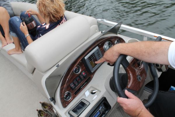
When I received the Garmin 441 the first thing I noticed was how few buttons it had. Its sleek "go with anything" design is very appealing and complements the dash console on my pontoon very well.
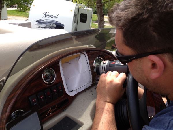
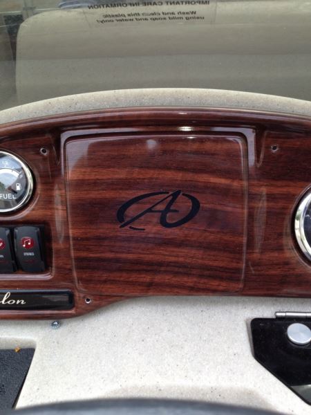
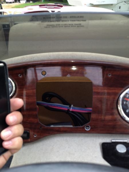
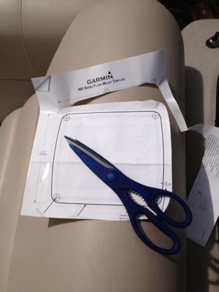 When I ordered it I didn’t realize I needed to have a dash kit too, so I purchased one online for about $14. The kit comes with all the necessary cutout templates that are basically a giant sticker. I simply placed it on and then followed the lines as I cut it out. The actual placement of the Garmin on my Avalon DRL pontoon was a breeze because this console was pre-designed in case I wanted to add this optional GPS later.
Hooking up the power was simple too, with the instructions being very clear and easy to follow. This particular model is not equipped with a sounder so all that was needed was a 12-volt and a ground. I simply ran the wires to the fuse block located in the helm and I was ready to rock and roll!
Before installing the unit I had some time to play with it a little to see how it was going to work. I used a simple 12-volt DC power supply and plugged it into the wall and I’m glad I had this time to play with the unit before the installation. For one, it built confidence in my ability to use all its functions and it also made my lake time more enjoyable not having to learn how to use it on the water.
The 441 came with a preloaded costal map, but unfortunately I live about 600 miles from the nearest coast so I needed to purchase a map for my area. The Garmin 440 comes with the inland lakes map already loaded so my advice here is to look closely at the models before you buy one since every model comes with a slightly different version of map preloaded onto it.
I had a lot of great options to choose from when it came time to pick the right map for my needs. Garmin has several versions of each map and some have more detail than others. I eventually decided on the "Inland Lakes" map.
It covers most lakes (boating size) in the U.S. and I also purchased the "Vision" map for Illinois. It covers all the rivers in my area too, plus a good amount of Lake Michigan. The Vision maps have all kinds of features that the regular maps do not, including auto routing, aerial photography, 3D imaging and a bunch of other cool features. The maps come on an SD card and slide into the unit very easily. The map must remain in the unit in order to use it, which does prevent another user from stealing map data. I purchased maps that were one season old to save money and together both maps cost me around $150. To buy them new would be around $450 and probably worth it if I traveled to more lakes and waterways than I currently do.
The Vision maps cost more than the regular base maps. Now that I have experience using both, I would recommend for general use boating the regular base map. If you’re planning on taking trips on unfamiliar waters, the Vision map does provide lots of information that would be useful.
To really get the most out of the unit you need to install Garmin’s HomePort software on your PC or laptop. The software is honestly the best way to get information to and from the unit. Plotting routes on the unit can be done, but it would take several hours. The software is easy to use and anyone with minimal computer knowledge can learn to navigate through it fairly quick. It's available on the Garmin website for around $30.
 Here is where having the SD card map really comes into play. Picking the wrong model for my area kind of worked out in the end. You can pop them into your computer and use them with the software and avoid purchasing a map just for the software. I used the software to plot several versions of my route, the entire route and also segments of the entire route. After I completed this I just popped a blank SD card into my PC, and exported the routes (tracks) to the SD card. After that I just put the SD card into the Garmin 441. It prompts you to transfer the routes, click "ok" and you’re done! You now have your planned trip plotted into the 441 and are ready to launch. I could write two pages about how handy the HomePort software is and can't stress enough that if you own a Garmin chart plotter you are not scratching the surface of its capabilities without using HomePort as well.
Just before launching, I turned on the unit and put in the "Vision" card in with the Illinois river system on it. I selected "where to" and chose the route I created using HomePort and like magic a nice line paved the way for me to follow on the screen. I was really glad I spent the time getting used to working the unit ahead of time when it was just plugged into my DC power supply at home. It enabled me to easily switch between to different routes I made, plus made the overall experience very easy and trouble-free.
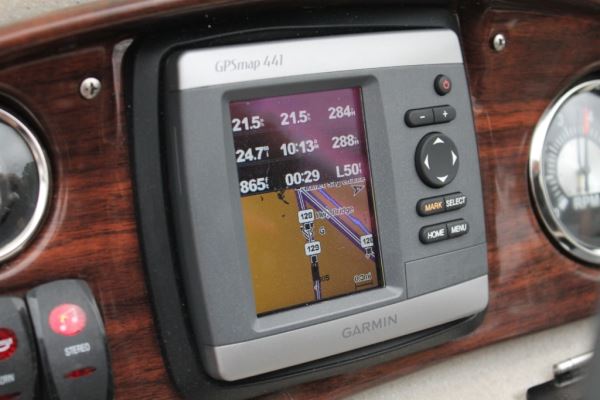
The screen is nice and bright and even has this cool feature that adjusts the brightness level automatically. It's clear and easy-to-read, even in the sun. If you choose you can display a variety of information like speed, ETA, heading, distance traveled, etc.
The ETA feature was very nice for our trip; it let us know just how far behind schedule we were! It was just as nice on the way home too; knowing if you need to speed up to make it back before dark is priceless!
Although our trip was pretty easy to follow there were times when I had to look at the line on the screen telling me where to go. The Chicago River has several large turning basins that can easily be confused with the main channel. The Garmin 441 made it a none issue!
Once we made it onto Lake Michigan I had originally plotted a course that was nearly a straight line from the Chicago River lock directly to Burnham Harbor. The lake was pretty rough and I wanted to alter the original course to keep us inside the sea wall as long as possible. It was very easy to adjust the route on the fly and continue on our way.
My dad lives in Florida on one of the several canals; this thing would be almost a must-have there. It is easy to lose you way in those canals and it would have been real nice to have during a fishing expedition of ours a few years back. That's about four hours of being lost I will never get back!
After we completed our maiden run I downloaded the trip back into the PC and was able to "re-live" it on the PC. It even records the time you were at a certain point. At first I really didn't see a reason for this, but later I thought how handy it would be to use the recorded trip for next year or to give to a friend.
 I have nothing but high praise for the Garmin 441. You will need to spend some time getting used to the functions and navigating the menus, as any product you buy will have a learning curve. It continues to function flawlessly. I have logged 88 hours on mine this season with zero issues (it has a neat little counter on it that says how long it's been on).
I would like to see a few things from Garmin. The software has a service called "Active Captain" that is a web-based service so users can put information into the maps, things like current fuel prices, good anchoring spots and even points of interest. I would really like to be able to get that info onto the unit. I would also like to see it have a Wi-Fi card built into it, for transferring routes to and from or even being able to tether it to a Smartphone for things like weather info, tides or sending and receiving your boat and others’ GPS locations. I know, I’m just dreaming!
I would recommend this product and any Garmin product to my friends. It adds a "cool" factor to my boat, safety, and the ability to go in unfamiliar waters without the worries of getting lost or in areas you should not be.
For more information on the Garmin 441 or any other Garmin products, visit www.garmin.com.